Measuring plate movement
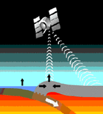
Earthquakes, Volcanoes and Mountain ranges are evidence of the plates moving. The Theory of Plate Tectonics suggests that Convection currents inside Earth Can affect the crust differently in the the different locations. You have seen how the plates have been moving since pangaea separated. Scientists can now use Satellite and laser technology to measure the plates exact movements. Laser pulses are now shot from the ground to a satellite to determine were the place it was shot from is on Earth. New data can confirm that parts of the crust are moving from 1-12 cm each year. For example the Atlantic Ocean is expanding and North america is being carried about 3 cm farther away from Europe every year. 24 GPS satellites orbit the Earth every 24 hours at 20,000 km above Earths Crust. Geodesy, the science of measuring the Earths shape and positions on it, lets us measure plate motions directly using GPS, the Global Positioning System.
